• Safely Track Me for Pilots

    Plan, fly and share your flight from one app

    Live tracking so friends, family and ops know where you are in the air, plus route planning, airspace overlays, fuel and wind calculations and a printable flight plan — built in.

    See the aviation features Not a pilot? Back to the main site
  • Safely Track Me in flight: live tracking with nearby traffic, airspace alerts and the altitude profile
  • Live flight tracking, built for the air

    Friends and family see where you are. You see what's around you.

    • flightLive traffic — see ADS-B, FLARM/OGN gliders and other Safely Track Me pilots around you on the map, with their altitude, speed and heading.
    • shareShare a live link — anyone can watch your flight in any browser, no account needed, and you choose how long the link stays live.
    • groupGroup tracking — for communities, flying clubs, flight schools and ops: everyone's track on one screen, live.
    • notifications_activeIn-flight alerts — avoidance warnings from an extensive South African obstacle database, spoken alerts for nearby traffic, and a heads-up on airspace changes, with the recommended frequency for the airspace you're in.
    • layersMultiple maps — street, terrain and satellite maps, plus a dynamic terrain map that changes colour as the ground nears your altitude.
    Route & airspace planning
  • Live tracking showing nearby traffic and an airspace alert
    Live tracking with a terrain and altitude profile against the planned airspace
  • Plan the route before you fly it

    Click your way across the map and Safely Track Me works out the rest — with South African airspace built in.

    • mapMulti-waypoint route planning — track, distance and recommended altitude for every leg, automatically.
    • terrainRule-aware altitudes — VFR/IFR semicircular rules, terrain clearance and controlled airspace, accounted for.
    • layersSouth African airspace, built in — colour-coded TMA, CTA, CTR, ATZ and danger areas, including the Johannesburg SRA's own rules.
    • settingsAircraft profiles — save cruise, climb and descent speeds, fuel flow, capacity, taxi fuel and reserve, used to drive every time and fuel calculation.
    • airBest cruising altitude, from the winds — forecast winds at each level (ECMWF and ICON models) are used to suggest the quickest, most fuel-efficient altitude for every leg.
    Weather & NOTAMs
  • Route editor showing a planned leg with airspace boundaries and an elevation profile
    Route plan with a fuel summary showing trip, taxi and reserve fuel against fuel at destination, driven by the aircraft's saved profile
  • Weather and NOTAMs, right on the map

    Live briefings where you're already looking, not buried in a separate app.

    • cloudLive METAR & TAF — tap any airfield for its latest reports, wind, temperature/dew point and QNH.
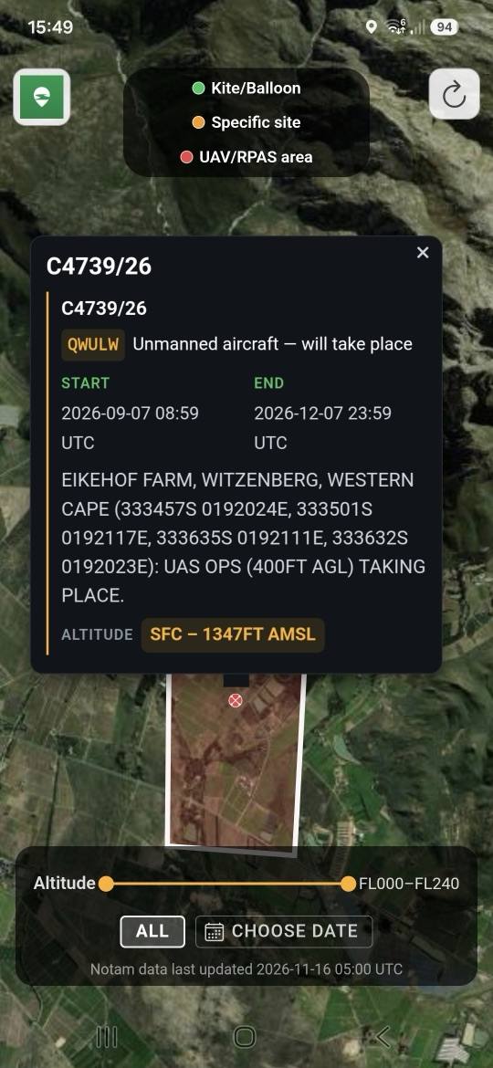
    • flagNOTAMs on the map — drone, kite/balloon and specific-site restrictions plotted with altitude limits and validity dates, filterable by date and altitude.
    • airLive winds aloft — the same Windy.com wind layer that feeds your leg-by-leg forecast, right on the planning map.
    • videocamLive airfield webcams — see the conditions at the field before you go, right on the map.
    Airfields & aircraft
  • Live METAR weather briefing for an airfield with nearby webcams
    NOTAM restriction overlay showing a drone operations area with altitude limits
    Winds-aloft forecast map with live wind speed and direction
  • Airfield and airspace directory

    Tap the map and know exactly what's there, whether you're planning at home or already in the air.

    • local_airportAirfields at a glance — distance and bearing direct, elevation, sunrise and sunset, frequencies, runways and notes from other pilots, plus fuel, food, accommodation and camping.
    • layersAirspace at a glance — tap any airspace for its name, vertical limits and the frequency to call, and step through the layers stacked above you.
    • near_meGo To — one tap from any airfield to fly direct, with distance and bearing all the way.
    Fuel, wind & flight plan
  • Airfield card for Morningstar showing distance and bearing, elevation, sunrise and sunset, frequency, runway and pilot notes
    Cape Town airspace on the map with the FACT CTR selected, showing its limits from ground to 2500 ft and the Cape Town Tower frequency
  • Fuel, wind and a nav log for ops

    Save your aircraft's performance once, and every route after that gets accurate time and fuel figures.

    • navigationWinds aloft, leg by leg — forecast winds feed your heading, ground speed and ETA, flagging legs too strong to make good.
    • local_gas_stationFuel planning — trip, taxi and reserve fuel, plus fuel remaining at each waypoint, with a shortfall warning.
    • picture_as_pdfA printable nav log — track, altitude, wind, heading and fuel per leg, a route map and elevation profile, ready to print or share.

    Planning aid only — always cross-check against an official flight plan and weather briefing before you fly.

    Contact Us
  • Flight plan PDF page 3: departure and destination airfield briefing
    Flight plan PDF page 2: route map and elevation profile
    Flight plan PDF page 1: route plan and leg-by-leg nav log
    View a full sample flight plan (PDF) →

Contact Us

Feel free to get in contact!

Contact Email

contact@safelytrack.me

Support Email

support@safelytrack.me

Play store logo Apple app store logo

← Back to the main Safely Track Me site